
Alone in the Void [Part 1] – Ascent of Mount Whitney, Elevation 14,505 ft: Solo Journey [Day I]
“Now, halfway up the infamous 99 switchbacks, in pitch-black darkness with only my headlamp illuminating the narrow trail ahead, I methodically place one foot in front of the other. Alone in the void of black space, all I have are my thoughts and the moon to keep me company. ”
~ Somewhere in the mountain’s shadow
Table of Contents
Day 1: The Journey Begins
5:00 AM – Wake Up in Lone Pine: Excitement and Anticipation
I wake up early, having spent the last couple of nights at the Best Western Plus in Lone Pine, following two days of pre-climb acclimatization at over 10,000 feet in Horseshoe Meadows—an essential step for many on the Mount Whitney hike to avoid AMS. The crisp morning air holds a promise of adventure, and as I scan my backpacking checklist, double-checking my gear and making sure to pack my Mount Whitney permit in a waterproof ziplock, a familiar blend of excitement and nervous anticipation stirs inside me. Today marks the beginning of my solo backpacking ascent.
I carefully double-check my Bare Boxer bear canister, a great ultralight solution for protecting backpacking meals from curious, hungry marmots as well as bears. I run through my backpacking checklist once more, ensuring everything is in place before packing up the car. The journey to Whitney Portal lies ahead, and with every passing moment, the thrill of the climb rises within me.
🌲TRAIL STEWARDSHIP: Bear Canisters
Bear cans do more than protect your food—they protect bears from themselves. If bears begin to associate food with humans and become too aggressive, they’re often put down by rangers.
6:50 AM – The Iconic Whitney Portal Arches
Arriving at the Portal parking area, I manage to find a good spot. The air is crisp, and there’s a quietness that only early mornings can bring. A few other hikers are finishing last-minute preparations, double-checking their gear and Mount Whitney permits as they get ready to set off. The energy feels both calm and charged, a mix of nerves and excitement that fills the space.
I make sure to stash any surplus food in one of the nearby metal bear boxes to keep it safe from bears, double-bagging it to ward off smaller pests like ants. Before starting the journey, I take a final stop at the portal restroom, realizing this will be the last man-made toilet I’ll see until I return to the car tomorrow. With hiking sticks in hand, my back brace snugly strapped on, and my backpack secured—packed with 24 pounds of gear, including two days of food, fuel, and less than 2 liters of water—I’m conscious of my backpacking weight, knowing that every ounce counts at high altitude. But with careful packing, I’m ready to begin.
Once again, I find myself standing before the iconic wooden arches of Whitney Portal, marking the start of my Mount Whitney hike. This time, I’m starting earlier than on my previous attempt, hoping to reach Trail Camp—today’s destination—with enough daylight to comfortably handle camp chores without feeling rushed. The early start brings a sense of quiet determination, and as I pass through the arches, the excitement of the journey ahead begins to take hold.
There are three main categories of ultralight backpacking:
⚙️ GEAR & TECH: Garmin Setup
For this solo Mount Whitney hike, I rely on what I like to call my trifecta of redundancy: my Garmin InReach satellite communicator, Garmin GPS Smart Watch, and phone to stay on course. Before setting out, I make sure all the batteries are fully charged, ensuring my navigation and safety systems are ready to go. I start the preloaded navigation course on my phone, which syncs with both my InReach and smart watch. This setup helps me track my progress up the mountain, with waypoints serving as checkpoints to keep me on the correct path throughout the climb.
💡 JEFF’S ANGLE: Trifecta of Redundancy
Trifecta of Redundancy is a phrase I use to describe having three separate but complementary tools or systems that serve a similar or shared purpose. This ensures that if one fails, there are backups to maintain reliability and safety. The Garmin InReach (on my pack) and Garmin smart watch (on my wrist) come into play, providing the redundancy I need to stay safe. I’ll explain in a future post why the phone is simultaneously this trifecta’s greatest asset and its biggest weakness.
7:20 AM – North Fork Lone Pine Creek & Mountaineers Route 💧
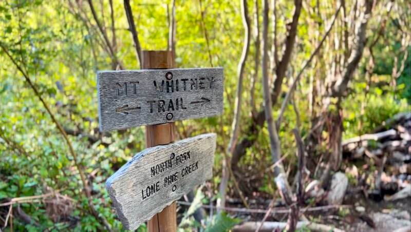
Not far from the start, just before reaching North Fork Lone Pine Creek, I spot a small sign pointing to the right, marking the Mountaineers Route. While it’s a shorter path to the summit, it’s much steeper and involves rock scrambling with significant fall hazards, like the Ebersbacher Ledges (E Ledges). This route is best tackled with a guide or if you have the technical skills to safely navigate its challenges. I stick to the main trail, knowing it’s the safer route for a solo Mount Whitney hike, with the goal of reaching Trail Camp by nightfall.
Just beyond this trail junction is my first water fill opportunity (WFO💧) at North Fork Lone Pine Creek. Here, I cross paths with a group of three hikers who are just as excited as I am to be on this incredible journey. We exchange greetings as they filter water, a reminder of the shared respect and thrill that brings us all to this challenging path.
I make sure to stash any surplus food in one of the nearby metal bear boxes to keep it safe from bears, double-bagging it to ward off smaller pests like ants. Before starting the journey, I take a final stop at the portal restroom, realizing this will be the last man-made toilet I’ll see until I return to the car tomorrow. With hiking sticks in hand, my back brace snugly strapped on, and my backpack secured—packed with 24 pounds of gear, including two days of food, fuel, and less than 2 liters of water—I’m conscious of my backpacking weight, knowing that every ounce counts at high altitude. But with careful packing, I’m ready to begin.
Once again, I find myself standing before the iconic wooden arches of Whitney Portal, marking the start of my Mount Whitney hike. This time, I’m starting earlier than on my previous attempt, hoping to reach Trail Camp—today’s destination—with enough daylight to comfortably handle camp chores without feeling rushed. The early start brings a sense of quiet determination, and as I pass through the arches, the excitement of the journey ahead begins to take hold.
There are three main categories of ultralight backpacking:
📖 DEFINITION: 💧WFOs, or Water Fill Opportunities
Typically available during this time of year but aren't always guaranteed. It's crucial to check with park rangers and online forums about current trail conditions before setting out. I will signify future WFOs with a 💧water droplet icon.
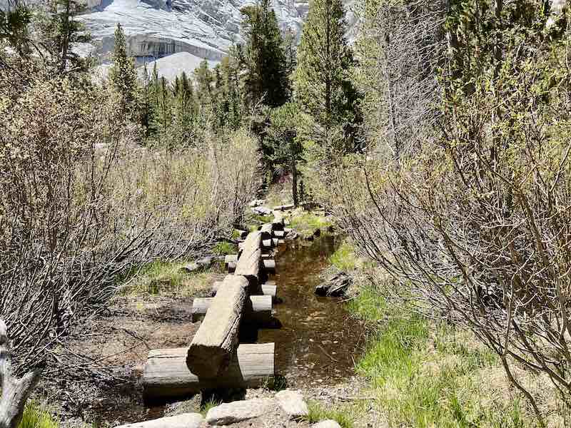
8:55 AM – Lone Pine Creek Log Crossing 💧
9:30 AM – Bighorn Park & Surprise Visitor 💧
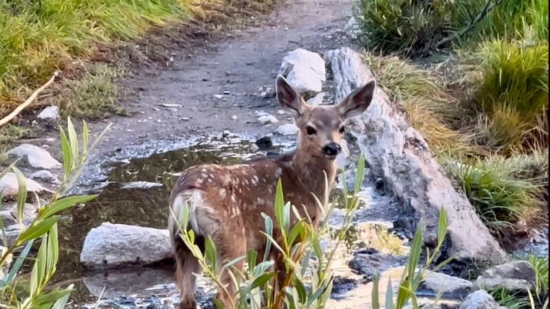
Arriving at the entrance to Bighorn Park, I’m greeted by one of the few flat meadows on the trail. This is the perfect place to drop my pack, grab a snack, and filter water if needed. The lush, green meadow stands in striking contrast to the rocky surroundings, a welcome sight after the morning’s climb. As I take in the tranquil scene, I spot a baby deer grazing nearby, its delicate frame moving cautiously through the meadow. It’s a magical moment, a gentle reminder of the peaceful beauty these mountains hold.
9:50 AM – Outpost Camp 💧
After walking through Bighorn Park, I soon enter Outpost Camp. Nestled beneath the trees just below the treeline, Outpost Camp offers a handful of primitive campsites, ideal for those with Mount Whitney permits planning a more conservative, three-day ascent. This added night here helps with acclimating to the high Mount Whitney elevation and the challenges that come with it. Outpost Camp is also an option for those on two-day missions, accepting a longer summit day for a more protected camp area than the exposed Trail Camp. Before I press on to Trail Camp, I decide this is a great spot to have one of my favorite backpacking meals! Whether for a two-day or three-day ascent, Outpost Camp provides a protected camping experience, especially beneficial for older hikers or anyone preferring a less strenuous itinerary.
📖 DEFINITION: Treeline
The treeline is the natural boundary where trees can no longer grow due to harsh environmental conditions, such as low temperatures, high winds, and thin air at high elevations. Above this point, the landscape shifts to open rock, alpine tundra, and hardy shrubs. In the Sierra Nevada, the treeline generally falls between 10,500 and 12,000 feet, marking the transition from lush forest to the more barren, rugged alpine terrain.
9:50-10:20 AM – Lunch Break at Outpost Camp
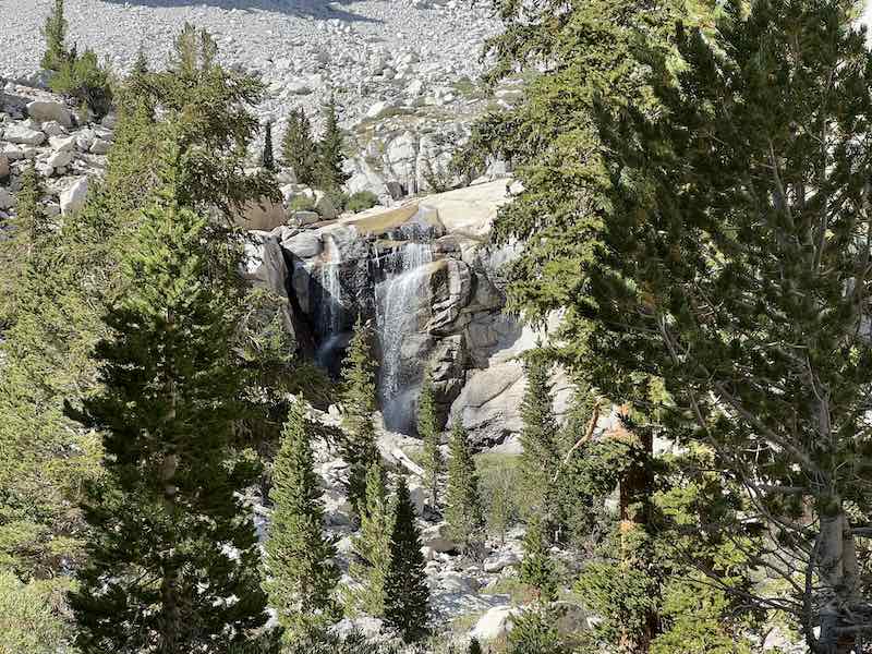
I decide to take a break here, setting up my Helinox Chair Zero and leaning back for a brief rest. The view is gorgeous—the seasonal waterfall just behind camp provides a peaceful soundtrack. The sun warms my skin, a comforting contrast to the cool mountain air. For lunch, I enjoy my all time favorite backpacking meal: chicken soft tacos made with flour tortillas, shredded chicken, hot sauce, and, honestly, some sad, wilted lettuce. The smoky flavor of the chicken, paired with the tang of hot sauce, makes this one of my favorite backpacking meals. Unlike a sandwich, tortillas are virtually smash-proof, holding up perfectly on the trail! It’s my last “civilized” meal before hitting the higher trail; from here on, it’s dehydrated food and packaged energy snacks, so I savor it while the sun filters through the trees.
Other favorite backpacking lunch ideas include things like Trader Joe’s dry salami sticks, cheese squares, and Nabisco Chicken in a Biskit crackers (a lifelong favorite), or sometimes even a pita bread sandwich—smash-proof and trail-ready.
🪶 ULTRALIGHT LIFE: Luxury Items
Adopting the ultralight backpacking lifestyle allows me to bring a few luxury items on the trail. By scrutinizing my gear choices, I reduce enough weight to make room for these extras. Sometimes, it's my ultra-luxurious hammock, but this time, it's my trusty ultralight chair.
10:50 AM – Mirror Lake 💧
After a steady climb, I reach Mirror Lake. On my first trip, it was one of the places I most wanted to see. This alpine lake truly lives up to its name, with its calm, mirror-like waters reflecting the steep cliff sides of the surrounding peaks. The tranquil sight offers me a moment of peace—a brief pause that renews my energy for the journey ahead. I take a moment to soak in the view. It’s sights like this that make the effort worthwhile—a perfect, still reflection amidst the rugged mountains.
11:45-11:55 AM – Trailside Meadow & Renewed Energy💧
An hour later, I’m happy to arrive at Trailside Meadow, another haven for weary hikers. This tiny meadow is fed by a stream originating from Consultation Lake, the tarn at Trail Camp, as well as snowmelt and rain runoff from the slopes above. I take the opportunity to filter some water and have a quick snack. I don’t take too much here, knowing that I’m only about an hour away from Trail Camp.
As I rest for a moment, a wave of excitement starts to build. After hours of climbing, I’m closing in on today’s destination—one step closer to my summit attempt. The thought of reaching Trail Camp fills me with a renewed energy. After a short rest and some electrolytes, I set off again, ready to tackle the last steep section with anticipation and determination.
12:25 PM – Lone Pine Creek Bridge & Future Missteps
Nearing Trail Camp, I cross a small rock bridge over Lone Pine Creek. The camp feels close now, and I’m savoring each small milestone on the way. But as I take in the peaceful surroundings, I have no inkling that this very section will throw me off course on my way back tomorrow, leading to a brief moment of confusion amidst the familiar terrain.
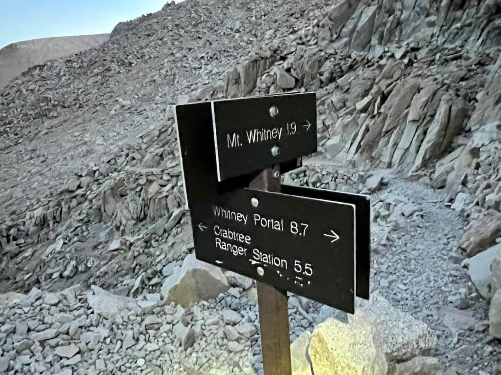
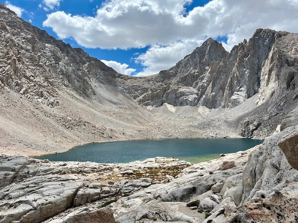
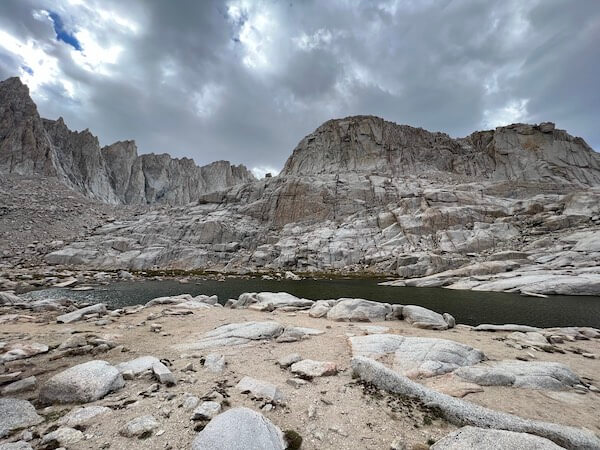
12:50 PM – Trail Camp & Consultation Lake (12,000 feet) 💧
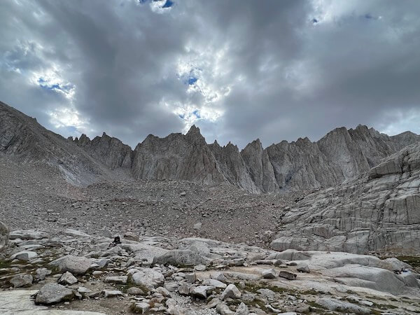
Now well above the treeline, I arrive at the iconic Trail Camp. Compared to my last attempt, getting here earlier feels like a small victory. Last time, the massive Consultation Lake was completely frozen over, and I had to wade through knee-high, sun-cupped snow on trail just to reach Trail Camp. Arriving late meant the camp was crowded, leaving few spots for tents, and I had to rush to finish camp chores before darkness set in.
This time, there’s no snow at Consultation Lake or anywhere else, and I have the luxury of taking it all in, feeling much more relaxed. To the right is the Trail Camp Tarn, the last reliable water source, and I pause to admire the massive rock towers rising above me. The 99 switchbacks are visible ahead, and to their right, I spot the section that becomes a snow slope in winter. For now, the slope is nothing more than bare, loose, exposed rock, unfit for climbing, but it’s easy to imagine the challenge it presents when covered in ice and snow.
📖 DEFINITION: Tarn
A tarn is a small alpine lake that forms in a depression created by a cirque glacier, often found nestled high in mountainous regions. These lakes are typically fed by snowmelt and rainwater, and are surrounded by rugged, rocky terrain. Tarns are usually crystal clear due to their glacial origins, and they can remain icy well into the summer months, depending on elevation and conditions. At Trail Camp, the tarn serves as the last reliable water source before the final ascent.
Conclusion: A New Day, A New Challenge
Reaching Trail Camp during my solo Mount Whitney hike has brought me one step closer to the summit, but the real challenge still lies ahead. At an elevation of over 12,000 feet, the unpredictable nature of the mountain can test even the most prepared hikers. As I settle in for a restless night, I can’t help but wonder: Will I be ready for the alpine start? Will the weather hold as I tackle the infamous 99 switchbacks on Mount Whitney? Tomorrow, I’ll face the true test, and the answers lie just beyond the break of dawn.